


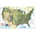
National Geographic: United States, The Physical Landscape 1996 - Historic Wall Map Series - 31.25 x 20.5 inches - Paper Rolled
Details
- ColorMulti
- BrandNational
- Map TypePhysical
- Paper FinishGlossy
- Sheet Size31.25 x 20.5
Description
🗺️ Map Your World with Style!
- COLLECTORS DREAM - A must-have for enthusiasts, showcasing the rich geological diversity of the U.S.
- ELEVATE YOUR SPACE - Transform your office or home into a sophisticated haven with this stunning wall map.
- CONVERSATION STARTER - This map is not just decor; it's a piece of art that sparks discussions.
- QUALITY YOU CAN TRUST - Printed on premium glossy paper, ensuring durability and vibrant colors.
- STANDARD OF EXCELLENCE - National Geographic's maps set the benchmark for quality and accuracy.
The National Geographic: United States, The Physical Landscape wall map is a beautifully detailed representation of the U.S., measuring 31.25 x 20.5 inches. Printed on high-quality glossy paper, this map is perfect for display in any setting, whether at home, school, or the office. Renowned for its iconic cartography, National Geographic ensures that this map is both a collector's item and a reliable source of geographical information.


Specifications
| Manufacturer | MapSherpa |
| Brand | National Geographic |
| Item Weight | 10.4 ounces |
| Color | Multi |
| Material Type | Paper |
| Sheet Size | 31.25 x 20.5 Inches |
| Paper Finish | Glossy |
| Manufacturer Part Number | 749717024380 |
Reviews
G**E
map helps students understand geography better
The students gained an understanding of US geography. Specifically to understand why early explorers took the routes they did. I laid it out on a table so the students could finger trace out the Oregon Trail, The Overland Trail, and The Pony Express Trail. As one student said “I feel like a pirate! Argh!” So they had fun, cracking pirate jokes while learning about US History
A**H
Great
I love this map because it’s oriented to the earth’s features, not political boundaries. But it has major cities so you know where you are.
Common Questions
Trustpilot
3 weeks ago
1 week ago
